Yesterday I dressed warmly, strapped on a snow shovel and a pair of snowshoes, and headed mountainward in search of deep enough snow to snowshoe in.
As I arrived at Water Canyon, a state police cruiser was exiting. As I parked, a four-wheel drive two truck arrived and started to head up the ice-packed road. I went up trail 13, one of my favorites, because there was certain to be snow on top.
On the way up I encounted lots of snow 8 inches or deeper. All powder, and all in shady areas on the sides of the mountain. No chance for snowshoeing, but it did make the hike extra tiresome as I plowed through it all.
The hike up was amazingly quiet. The air was perfectly still, and the canyon was deathly quiet.
Up top, the stillness ended, and a bitter cold wind blew across the mesa. I'd packed with the plan that I'd add my windproof layers last, but I was too warm for the stuff on top of my pack and needed the shells, so it was a pain to dig them out. At some point, I took my googles off, and forgot to put them back on. I'm not really sure how long I had them off, but I didn't seem to burn my retinas, so it must have been thankfully short.
I took a few silly pictures of myself up top with my camera in the self-timer mode balanced on my snow shovel which was on top of a mound of snow. I set up my hammock and laid around for a while looking up at how crisply green the trees were above me (in retrospect, it was probably the tint of my googles that made them look so good), and then headed back down. Descending the trail was a lot more treacherous than ascending it had been, but I made it.
I took pictures, but I'm not sure any of them are interesting enough for a follow up post, but I might put some up anyway.
Sunday, December 6, 2009
Sunday, November 29, 2009
Two Weeks Have Passed...
Two weeks have passed, and the only pain I've had was when I had a misadventure with the corner of a box. I went on a vigorous walk a week ago, and there was no indication that it aggravated my surgery.
I shall soon be trying again for more adventures in the mountains. I think I'm finally recuperated enough.
I shall soon be trying again for more adventures in the mountains. I think I'm finally recuperated enough.
Tuesday, October 27, 2009
Still Not Better
I suppose I should keep this somewhat up to date.
Me and my surgery are still at odds against each other as to whether or not I'm better. Someday I'll be able to stand up and walk without pain...
Me and my surgery are still at odds against each other as to whether or not I'm better. Someday I'll be able to stand up and walk without pain...
Monday, October 12, 2009
Walking
I walked about 8km yesterday, not sure I mentioned that earlier. I think I walked about 3.8 miles today. I definitely feel sore from yesterday. And tired from today. I over dressed for today. It was hotter out there than I imagined.
Gear
I replaced the green Marmot jacket I'd lost. Then I found it. It had made it back with me. My cats had taken it, and hidden it from me. Along with it I also found a backpack that had been missing for quite a while.
At REI yesterday I picked up a Smartwool neck gaiter, some Smartwool glove liners, an OR balaclava, a The North Face hat, and a couple of other things. I should be well prepared for hiking/walking/bicycling in the cold this winter.
At REI yesterday I picked up a Smartwool neck gaiter, some Smartwool glove liners, an OR balaclava, a The North Face hat, and a couple of other things. I should be well prepared for hiking/walking/bicycling in the cold this winter.
Serious Lack Of Progress
 |
| From 2091011 |
Once again I'm ready to declare that I've recovered from my surgery. Who knows if I'm right?
Yesterday I hiked in the forests of Santa Fe because it's about the time of year when leaves change. I don't have pictures offloaded yet. For the most part, I missed the change. I was told that a week before not many had changed, and by yesterday many had finished and already dropped their leaves. Oh well. I went about 8km I'd guess. I forgot to turn the GPS on at the start, and I forgot to turn it off before driving away in my car.
Wednesday, September 23, 2009
More Walking...
Last night, after gaming, I walked to Jason's house. He says it is a little more than a mile from his house to the plaza, and it is about half a mile from my house to the plaza, plus I took a trip around the field and a slight Northern detour on the way home. That should be at least 3.5 miles last night. By the end of it my back was feeling sore, and I was feeling tired, so I know I put some effort in. I haven't done much since the surgery, with last night being only my sixth time out walking or hiking since August 5th, but things are looking up.
Monday, September 21, 2009
Getting Back Into It...
Tonight I walked 1.33 miles around the track, and another 1.5 or so miles getting to the track the long way and then detouring to Cooney's. Last night I walked 2.5 miles, so it was a tad bit of improvement.
I didn't hike on Sunday because I slept in after responding to a 04:30 alarm call at work. I didn't hike the Sunday before because I was too sore from the Saturday hike. I forget what the mileage was on the Saturday hike. But now I've done this two days in a row, which is progress!
I didn't hike on Sunday because I slept in after responding to a 04:30 alarm call at work. I didn't hike the Sunday before because I was too sore from the Saturday hike. I forget what the mileage was on the Saturday hike. But now I've done this two days in a row, which is progress!
Saturday, September 12, 2009
Hiking Soon!
I seem to have packed up 11.6 kg of stuff. I'm carrying extra things that I don't need to make the pack heavier, such as two hammocks and my largest tarp. I also have three liters of water for a hike that is planned to be 4km.
Monday, September 7, 2009
4km Walk And Jacket Failure And Sunday Plans
I did a 4km walk since I last posted. Not much, but it still hurts when I do certain things.
I also discovered that my new jacket appears to have remained in Turkey Creek. I'm pretty sure I lost it after getting hit by the rock. I needed to get stuff out of my pack in the aftermath, and I apparently didn't put it back in. I don't remember losing it, so this is just a guess though based on the fact it was the most likely time for it to have happened. So now I need to replace it already, which sucks.
Sunday, coming up, I want to hit Copper Canyon again. But I have yoga class at 13:00. So I'm suspecting Copper will be an extra-early start and we will try to rush it. I'll pack super-light (hammock and water) to facilitate this.
Sunday, August 30, 2009

Death By Mountain Nearly Achieved!
While taking the rather direct route straight up the side onto the trail yesterday, I encountered a falling rock. It was about 2' across, and it came down in a direct path to strike just left of my sternum. As steep as the hillside was, it seemed pretty unsurvivable at the time. I got my trekking pole up and it took the brunt of the impact for me. I'm out $200 to buy a new pair of carbon fiber trekking poles, but minimally injured.
I also fell into a water filled rock cut while I was trying to photograph it. I hurt my knee pretty badly in doing so. The water sluiced me down the cut and dumped me over a waterfall into a pool. Waterproof cameras are great for these outdoorsy pictures! It would have been a blast if not for all the limping from the knee.
My hiking companion was totally unprepared. Instead of going on a Friday campout, Saturday backpack in, Sunday backpack out, I did a 16km hike with a heavy pack that I didn't use nor need. I made my destination though, and I took pictures to prove it. As soon as I can find my card reader, I'll get them offloaded and then uploaded.
Friday, August 28, 2009
Thursday, August 27, 2009
Packing
I bought myself a Berkley 23kg hanging scale. It's for fish.
Gregory Z-55 backpack, 1.67 kg.
Leaf bag, 1.70 kg.
Wiggy's 35F sleeping bag, 3.13 kg.
OR bivy sack, 3.68 kg.
5' by 8' silnylon tarp, 3.88 kg.
6 stakes and 100' guyline, 4.05 kg.
Hammock, 4.63 kg.
3 Tasty-Bite, M&Ms, dried cherries, crackers, peanuts, 7.01 kg.
SmartWool long underwear, 7.36 kg.
Water filter, 7.77 kg.
9 LED headlamp, 8.0 kg.
GPS, 8.18 kg.
Rain pants, jacket, gaiters, and hat, 9.21 kg.
Junk bag, 10.21 kg.
2 AA batteries, 10.26 kg.
Digital camera, 10.54 kg.
Socks, underwear, t-shirt, shorts, 11.13 kg.
Sandals, 12.19 kg.
2 Nalgene bottles, 12.41 kg.
Balaclava, 12.44 kg.
Salmon, 12.71 kg.
This doesn't count what I'll wear:
Shorts, underwear, t-shirt, socks, boots, trekking poles, and sunglasses. The hat, GPS, and gaiters listed above might be worn as well. Also, I'll have water in my water bottles.
I also added in some ziplock bags and a spare leaf bag, which take the total weight up by a tad bit more.
Sunday, August 23, 2009
Googles Maps and Turkey Creek
Turkey Creek and Skeleton Canyon. I've always turned right here, and gone up the creek to the springs instead of ascending the ridge. We come out on the ridge.
View Larger Map
Google maps is broken, but I can reverse engineer the location to wedge it here in.
View Larger Map
Google maps is broken, but I can reverse engineer the location to wedge it here in.
Scales And Food
Right now I'm looking around the internet for hanging digital scales. A hanging scale would make it easier to weigh a lot of my stuff.
I'm also wondering about what food to pack. Unsalted peanuts are definitely going to be going with me. Probably peanut M&Ms too, despite the fact that I really don't like the ingredients that M&Ms are made out of. I don't want to cook (and I especially don't want to clean pans), so no pasta. Some cucumbers might be nice. Apples as well.
I'm also wondering about what food to pack. Unsalted peanuts are definitely going to be going with me. Probably peanut M&Ms too, despite the fact that I really don't like the ingredients that M&Ms are made out of. I don't want to cook (and I especially don't want to clean pans), so no pasta. Some cucumbers might be nice. Apples as well.
Saturday, August 22, 2009
Getting Ready For My First Backpacking Trip In A Decade
I'll reach a landmark in my attempts to overcome a decade of fatness and laziness on Friday of next week. I'm backpacking in to Turkey Creek Hot Springs in the Gila. It's about 4 miles, with 3 river crossing and 7 to 9 stream crossings. I don't get my stitches out until Wednesday after the trip, but I won't let that stop me. Good clean mountain stream water is good for surgery.
I just packed up a pack with a set of most things I'd conceivably take. It seems to weigh a little less than 10kg based on my person-scale. Heavy by modern ultra-light standards, but nothing compared to absurdly stupid packs I used to carry in search and rescue.
And now, in a sense "live", I'm going to itemize and individually weigh what I packed on my kitchen scale.
The pack I'm taking is a Gregory Z-55. I guess I'll weigh it at the end.
My junk bag, since I last wrote about it, has had a fifty foot length of Kelty trip-lite added to it. After losing my pack over the edge in Water Canyon early this month I decided to add an ounce of strong rope to help out the next time I'm in that situation. The junk bag now weighs 1000 grams. Maybe I should prune it again. But everything inside the bad is pretty useful.
I packed a mesh bag with three Tasty-Bite Madras Lentils, a mini cliff bar, and a small spoon made of aircraft aluminium. This isn't enough food, but it's a start. I like the Tasty-Bite meals, and will probably take the three with me. Food so far weighs 976 grams. More needs to be added. The spoon isn't useful; I can squirt the Tasty-Bite into my mouth quite easily.
My new bivy sack weighs 540 grams.
The LED headlamp I picked out weighs 226 grams. I have lighter ones.
Stakes and guylines for setting up a shelter for my tarp weigh in at 164 grams. I probably have more stakes and more guyline than I will need.
I'm still blinded from having stared into my 9-LED lamp to see if there were batteries in it.
My GPS weighs in at 182 grams.
My water filter is 412 grams.
A mesh sack with gaiters, waterproof jacket, waterproof pants, and waterproof gloves is 1084 grams. I probably only need the jacket and gaiters.
A hammock to sleep in is 570 grams.
A mesh sack with my new SmartWool microweight wool pants, microweight long sleeve top, and microweight short sleeve top is 540 grams. I may not need any of it.
A 5' by 8' silnylon tarp is 198 grams.
All that's left is the sleeping bag, a 35F Wiggy's. I'm not sure I can weigh it on the scale I have. Nor do I think I can weigh my pack.
I didn't have any water packed, so add in maybe 300 grams for two plastic bottles, plus the weight of the water. I also need more food. Not sure how much that will weigh since I haven't made up my mind what it is. I don't plan to cook, so there won't be a stove or pot. I'll also have my new waterproof digital camera with me, which adds a little weight too.
Sandals will be included, and several pairs of socks. Boots for hiking, but sandals for crossing the water.
Overall, the pack doesn't feel that heavy. Water, food, and footwear will add a little more, but I have things I know I can remove as well. It should be a good hike.
Oh, and it's only been eight years since I backpacked, but a decade sounds better.
Thursday, August 20, 2009
More Progress
And some failure! My pre-walk plans fell through last night, and I ended up being distracted by killing time, and I didn't walk. Not a terrible loss I suppose.
Today I had my first yoga class. I'm taking private classes because since yoga began to interest me in about 2004 I have yet to encounter a yoga class held at a time that is good for me. The private lessons still aren't the best, but they get me much closer. I think I'll enjoy the one-on-oneness a lot as well.
I didn't learn any secret yoga fighting moves to defend myself during the zombie apocalypse yet. I did learn a defensive pose to use in case I'm trapped in a hurricane.
Tuesday, August 18, 2009
Progress
Today I rode my bicycle to Supermart twice, and then I walked. I just returned. I walked about 3.3 miles. It went pretty well. I also had five people who tagged along, which is a record.
I also went to meditation class again yesterday, and on Thursday I take my first yoga lesson. I told my yoga instructor that one of my goals was to learn the secret yoga fighting techniques I'll need to survive the zombie apocalypse. AND I told her that before I'd seen that paper on the zombie apocalypse. Actually, I suspect that the google ad for it popped up solely because I just sent an email about the zombie apocalypse. Google is tricky that way.
In nine days I'm headed four miles into the Gila Wilderness through three river crossings and seven to nine stream crossing. I'll also have to crawl through one cave in an otherwise impassable box canyon with a waterfall rushing through it. The goal is a 186F hot spring.
Wednesday, August 12, 2009
Hiatus
I realized I should post something here just in case someone reads this who doesn't know me.
Just after the last post I had surgery, and I'm not expected to be able to do anything for a month or two.
Just after the last post I had surgery, and I'm not expected to be able to do anything for a month or two.
Monday, August 3, 2009
Mountain Biking In The Bear Mountains
Yesterday was another overly ambitious day. A week previous, we had driven out to the base of Hells Mesa and climbed up. We had originally overshot the turn off, and when we turned around the road had become quite interesting with lots of colourful rock outcroppings on both sides alongside the twisty and hilly roads. It seemed like a nice place to ride. So yesterday, we went back out to ride. We parked quite a ways from the interesting spot, so we had a lot of riding to get there. On the way we diverted down a couple of side roads, one to the end of the road, and the other to a rattlesnake.
We also stopped once to hammock in a smalls stand of piñon. Around the time we arrived at the interesting part, Brad's front tired suddenly lost pressure. We turned around and headed back. His tire was low, but seemed to be holding out well. He made it most of the way back before it suddenly flatted out completely. He pushed for a while, then abandoned it and started walking. I tooled along beside him alternating between walking and riding. Eventually he hitched a ride to his truck and I continued on. He picked me up at 50.3 km into my ride that day, just as I had stopped to photograph a transmission someone had thrown into a ditch.
In the long run, it's fortuitous that we turned around when we did. Both of us were wiped out from the ride. I suspect that it was once again the noontime sun that really did us in. It was hot out there.
I have a tracklog and pictures that I'll get to at some point.
Friday, July 31, 2009
Gear Ruminations Again
Back in June I pulled my backpacking gear out and went through it. Most is in fine shape, some of it needed replacement because it was defective, and a few things needed replacement because my corcumstances have changed.
Consider my bivy sack, for instance. I have an OR Advanced Bivy sack. It retails for $299 (currently, it was cheaper back in the 90s), and is pretty much the ultimate mountaineering bivy sack. Before owning that bivy sack I once spent three days buried in the snow in a blizzard. I had a tarp and a garbage bag then. At one point I discovered for some bizarre reason that there were some frozen hot dogs down near my feet. I bent one of them and it made a terrible cracking noise, and at that point I realized that a) my toes were frozen, and b) that was a toe not a hot dog.
SAR was (and still is) an unpredictable trip planner. When I bought the bivy sack, it went into the SAR pack. Only the most durable and hardcore bivy sack would do. SAR missions are spontaneous, and often take you into bad weather. The state policy had been that teams should expect to be out 8 to 12 hours, but should be prepared for 24 hours. George had us be prepared for 48 hours, and on a big search in a remote area he might send you out on a single mission for as long as three days (there are no roads in wilderness areas, so remote searching requires a lot of hiking). Back then missions were long too, since people didn't have cell phones and GPSes. I spent a week searching for a young boy named Michael, and I didn't come the first day, and I left long before it was over. His body was found years later.
I'm not very much in SAR anymore though. I moderate the mailing list, and sometimes I think I should join AMRC for the excitement and difficulty of their training, but for the most part, I don't do SAR. My bivy sack is heavy, so I bought a new one. It is still an OR bivy sack, but this time it's the lightest sack they make. I'd say that most of the time it will still be overkill for what I need, but not as much overkill as the OR Advanced Bivy, and it saves me a noticeable amount of weight and size.
Since I was replacing my bivy, I decided to replace my long underwear too. I have three pairs of it. My black pair I purchased in 1991 or 1992, and is the kind of polypro that retains odors. They've been through a lot with me, and have some holes in them, but are still in good enough shape that I wear them. Sometime in the late 1990s I bought a set of white capilene long underwear. I haven't worn them as much as the black ones, so they are better shape, but they look worse because the color shows stains more easily. My final pair is a set of very heavyweight long underwear that seems to be military surplus. They've never been worn in the field, just around my house in the winter. My new underwear is a set of SmartWool microweight long underwear. I'm very interested in going back to being a wool-wearer for the cold weather. Wool is nice stuff, and merino wool is extra nice. I had planned to wait until winter, but plans have changed. I might make an Augusth 12th midnight ascent of Copper Canyon, and if I do, I'm pretty sure I won't be wearing shorts up there.
There is also gear I need to purchase for the first time. I hope to go up Ladrone this winter. And if I do, I need crampons. Admittedly, I have made it up Ladrone without crampons and I'm sure I could do it again, but I think I'd rather have crampons. I've never bought crampons before. Not only will I need to get crampons that fit the boots I currently have, but I should make sure they fit the boots I plan to upgrade too.
Losing my pack over the edge at Cold War Cave has led me to believe that I need to carry rope in it at all times. All it needs to be able to do is hold the weight of a pack, so a 50' length of the Kelty triplite would be idea. It holds far more than my pack will ever weigh, and it weighs nearly nothing itself.
Thursday, July 30, 2009
Wednesday Night Walk
 |
| From 20090729 |
Walked around with John. Was hassled a little by campus police because Billy Romero doesn't think that public property is open to the public. Went a little over 9km in two hours.
Wednesday, July 29, 2009
Tuesday Night Running Failure
My gamers were clearing out nicely by 22:00. Jason asked if I was planning to run at Clarke Field, and I said I was, so he said he'd walk over with me. Instead of departing at the field, he walked around it with me. Then again. And again. An hour and forty minutes later, I noticed what time it was and how long we had been at it. We went around a couple more times, then each headed to our own homes. So I got in two solid hours of walking and no running. I'm guessing it was probably about 10km, but I have no way of knowing for sure.
Monday, July 27, 2009
Further Monday Night Adventures
Walked 1/4 mile. Ran 1/4 mile. Walked 1/4 mile. Ran 1.4 mile. Walked 1/4 mile. Ran 1/4 mile. Walked 1/4 mile. Ran 1/4 mile. Walked 1/4 mile. Posted about it on the internet.
Meditation
Along with all this hiking and walking and (sometimes running) and (soon to be) mountain biking, there is yoga and meditation on the horizon. Meditation happened today, at the yoga place. Yoga doesn't start for a few weeks yet. All in all, I managed to sit through the two meditations we did quite successfully. I fidgeted less than my future yoga instructor did. On the other hand, she had all kinds of things to say about the experience, while I was left with feelings that I was itchy, and that I didn't know how to contemplate things. I didn't participate in the group discussions at all because of it. I may not make the next session, but I'm certain to go back.
Sunday, July 26, 2009
Cold War Cave
 |
| From 20090726 |
 |
| From 20090726 |
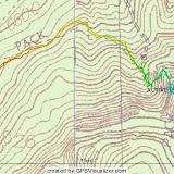
Today we hiked up to a place in Water Canyon that I refer to as Cold War Cave. Back when I used to go there a lot, during the cold war, we didn't really have a name for it. It's quite close to the campground, but there is no trail. Not only is the mountain quite steep, but towards the top it's bathed in scrub oak. I lost a lot of blood on the way up. On the way down, I put my gaiters on, and it was much more pleasant. The pass into the valley seemed different, and once through it I discovered that I had taken the right one instead of the left one. The left one (as you face it from the bottom) has a jumble of rocks with a corkscrew gap that you can wiggle up and down.
The valley itself is steep and brushy, but small and semi-sheltered. There are lots of overhangs, small cracks, and a couple of small caves. The cave we had planned to hide out in after nuclear war is a deceptive dead end cave with a side tunnel hidden on the left. The tunnel goes in, turns, and has a side room off of it. It isn't big, or glamorous, but for a post-apocalyptic world it would do nicely. It would need work to level out the floor, and it would always be extremely dark inside.
The trip down was quick. In the corkscrew rocks I dropped my pack down into the first hole. It ended up tumbling down and went over the edge. My nice metal Sigg bottles didn't take it very well. The camera I had with me was too slow to catch it going. Once I had managed to climb down to it I was taking pictures when Brad lost his pack in a different part, but it also came out and shot past my head. I didn't get a picture of his pack flying through the air either.
As you can see above, the GPS tracklog and profile show problems. The new GPS is more sensitive, and does a much better job, but there were lots of places where I was underground and it just isn't sensitive enough.
Hells Mesa Report And Pictures
There are three things you should know about Hells Mesa.
1) There are no trails.
2) There are no trees.
3) There is no water.
Those three things appear to describe the entire area, not just Hells Mesa. I got the idea of going to the Bear Mountains because the Forest Service had mentioned that no one goes there. Well, there's a reason no one goes there. They suck. At least, in the summer they do. I suspect they might be very pleasant in the spring or fall.
We headed out looking for a FS road that took us to a spring on the South side of Hells Mesa. We missed the road because it wasn't marked, but found it on our second trip back through the area. There is an old house towards the end of the road that someone put a lot of work into. It must have been a nice place back when it was inhabited.
Since there are no trails, we just headed up the side that looked easiest from the topo maps. It worked out well enough. Hells Mesa isn't really much of a mesa. It's more like a ridge, but without peaks on either side of it. On top we discovered a lot of tarantula hawks, but no sign of any tarantulas. There was one dead tree, which I hammocked in. But one tree doesn't hammock well. Brad tied his hammock off to the tree and a bush, and elevated the bush end with a rock. It kept him barely off the ground. Not to be outdone, I did the same, but elevated my bush-end with my trekking poles.
We went down to the West, and looped around back to the truck. All told, it was a short trip. But the rough terrain and the steepness of the ascent made it a hard trip. The sun was brutal.
I regretted not having replaced my climbing helmet yet. If one had been with me, I'd have been wearing it. This was also the first hike with actual pain and injuries. I took a stick to the stomach and bled. Loose rocks elicited painful screams from both of us during the treacherous descent.
Mesa Trail #13 on July 19th
 |
| From 20090719 |
It was a fairly long hike over an easy trail. We went up the Northernmost part of 13 and hammocked at the top. From there, we headed South and did the loop that hits the two scenic viewpoints going widdershins. After the first viewpoint the trail went bad on us. It was missing in many places, easily misplaced in others, and plagued with fallen trees just about everywhere. We lost the trail and had to backtrack a few times. It was rather pleasant. Once we made the loop, I took a left, mistakenly believing the fork I wanted was in that direction. It wasn't, but we got extra hiking in as a result.
Once again, the trip down was the worst. We were already tired, and the sun was unbearable. Our conversation drifted from small talk into length discussions about exactly how much water we had left. At some point during this hellish part of the hike, I announced that it was too hard and I should go back to sitting at home stuffing myself full of delicious food and getting all my exercise from playing WoW. Brad reminded me that my goal was to die by the Mountain, and not from diabetes, and he's right. Then I realized that if I didn't bring water on hikes like these that I'd easily achieve my goal.
Overall, it was a decently long hike. The brutal sun was the worst part of it. Again, I hadn't taken enough water with me.
A gallery of a few of the interesting photos follows.
Saturday, July 25, 2009
Hells Mesa Profile And Tracklog


Thursday, July 23, 2009
Update!
Monday I ran. I think I already posted that here. Tuesday I was tired, and starting to hear things, so I decided to sleep instead of doing anything Tuesday night. Last night, Wednesday night, I did a 2.5 mile walk.
Still no pictures available from the Mesa Trail hike on Sunday. My hard drives filled up the day before on Jason's wedding, then my ethernet switch went out leaving my computers isolated from each other and the internet. Things were mostly back to normal, but I did a partial upgrade of my server and ended up crippling useful programs like emacs because I didn't upgrade everything. So I have bigger problems still than getting those pictures online. Soon though, I hope.
Saturday I plan to hit Hells Mesa, and Sunday I plan to hit an old cave me and my friends had planned to hide out in when Russia nuked the United States back during the cold war. Neither should be very long or strenuous.
Monday, July 20, 2009
Running
No pictures yet from Mesa Trail. I'm fighting hardware failure in my home network and a full hard drive.
Tonight I went to Clark Field and I ran four laps. I wasn't anywhere near fast, but I was doing a lot more than just walking. suspect I could have run more laps as well, but four laps is enough since my last attempt at running on netted me something like 370 meters.
Tonight I went to Clark Field and I ran four laps. I wasn't anywhere near fast, but I was doing a lot more than just walking. suspect I could have run more laps as well, but four laps is enough since my last attempt at running on netted me something like 370 meters.
Sunday, July 19, 2009
Mesa Trail #13 Tracklog
 |
| From 20090719 |
All total we went a little short of 16km. I'm not nearly as beat as I was last week. The trail is bad in lots of places.
Thursday, July 16, 2009
Last Nights's Walk
Went on a walk around on the Clark Field track last night. Did 10.1km in about 150 minutes. An old toe problem is returning from my days of running. I forget the name of it, but I remember the solution: athletic tape! I wore my new fancy wicking boxer shorts, and my wicking The North Face t-shirt, and overall I was quite pleased. Previous experiences in nighttime walks were not as pleasant due to the sweat, but the wicking layers kept me dryer despite the hotter night last night.
Tuesday, July 14, 2009
GPS Comparison
My Gecko 201 weighs 112g. My eTrex H weighs 182g. I paid $117.99 for the Gecko 201. I paid $81 for the eTrex H.
Now compare tracklogs. Both were set to 1m recording intervals. One is definitely more accurate than the other. It's the eTrex H.
Now compare tracklogs. Both were set to 1m recording intervals. One is definitely more accurate than the other. It's the eTrex H.
 |
| From 20090714 |
Monday, July 13, 2009
Tonight's Adventures
Most recently I went to Clark Field and walked around it many times. I went two miles, but was thwarted from going farther by an upset stomach.
Earlier today I drove out to the ranger station in Magdalena. The guy manning the front desk was useless. But I kept asking him questions until he passed me off to one of the guys in an office. The new guy wasn't nearly as useless, but he still couldn't answer most of my questions. Eventually he passed me off to someone else, who just happened to have all the things that the first two had no idea about. Perhaps the most interesting thing I learned is that the Cibola National Forest has a trail crew now. It's been at least a decade since they had one.
I think Clark Field will need to become a somewhat regular part of keeping my legs moving. It's close and reliable. No hills or interesting terrain, but it saves a tremendous amount of gas since I don't have to drive to it.
Because of the troubles I've had with track logs I bought a different GPS. The new one is cheaper, still has 10,000 tracklogs, and boasts a more sensitive receiver than my Gecko 201. The forest services guys prefer it to the $3000 professional Trimbles that they are given by the forest service.
Sunday, July 12, 2009
Yesterday's Pictures
Some of the more interesting pictures I took yesterday.
I'm still very sore today.
New Gear
Thursday of last week I went to REI to pick up some new shorts and a titanium cooking pot. Both had been on sale, so it was a good deal.
While at REI, I picked up an MSR nano pack towel because I felt I needed it, and browsed the sale racks in the store. I found a button down shirt that I can use at work for those rare days that a customer comes, and a The North Face t-shirt that was only about $20 instead of $30. The regular cotton t-shirts I wear have proven to be hot and sweaty. The North Face t-shirt was horrendously over priced, even on sale, but the promise of superior materials lured me into it. It also had the benefit that the shirt was cut so that there wasn't a seam on the shoulder, which should make it more comfortable to wear with a pack.
I wore the t-shirt yesterday for Copper Canyon, and it was well worth it. I wasn't sweaty, I felt cooler, and it was more comfortable. I still think it is horrendously overpriced for what it is, but I don't regret buying it. I may even buy another, and pay full price if I can't get it on sale.
I also put the nano pack towel to use. This new towel is vast improvement over the pack towels I owned in the 1990s. I bought it to clip to my shoulder straps so that I could use it to wipe sweat off my face. I've had trouble with sweat dripping into my sunglasses, and my only recourse had been to squeegee my face off with my fingers, which isn't effective. The new pack towel worked well. I might need a slightly bigger one though.
Yesterday's Hike
Dave came down from ABQ to go on the hike. Like me, he wants to be fit and healthy again. We headed out and parked at the Water Canyon picnic area. From there it is about one mile to the trail head. The hike up Copper went amazingly better for me this week. Last week I required two hammock breaks on the ascent. Yesterday I blew through where I'd taken the first hammock break with no trouble. When I got to where I'd taken the second hammock break I could have kept going, but it seemed like an ok time to stop, so we took a hammock break there.
We pushed on and made it to the fork in the trail that we had encountered the previous week. Past that, we found another fork in the trail. The second fork we found was the fork marked on the map, so my distance guesses for the previous trip where short by maybe half a mile. I have no idea what the first fork is now. It is a real fork, with blazes and maintained trails, but there are no signs. Perhaps we shall have to hike it to find out where it goes.
I still felt good, so we moved on through the fork heading up towards trail 8. The final climb out of Copper Canyon was a bit brutal, but eventually we reached a point where we could look up and see sky instead of just seeing more mountain. One up on the ridge it was a wonderful treeless and grassy meadow with rock cairns to guide the way. We headed back roughly parallel to the trail we'd come up on trail 8, under the assumption that was the trail that would take us to the Langmuir road. It cut through the trees South of South Baldy. We encountered some hikers along the trail, and I asked them where the trail we were on went too. The guy feigned ignorance at knowing where he was, but did admit the trail we were on was in fact the trail we thought it was, and we were quite close to the end.
At the road, we headed down to the top of trail 11. At trail 11 I admired the tire tracks left through the meadow by people driving around in the grass, and then we showed my map to two hikers who were unable to locate the trail they were looking for. The trip down trail 11 was brutal. I'd felt pretty good up until this point, but I hadn't taken enough water, and I hadn't been adequately drinking the water I did have with me. Trail 11 is steep and hot. The sun was unrelenting. By the bottom of the trail I was seriously considering just collapsing.
Eventually we emerged onto the road. I was beat. And there was still a bit of road hiking to do. I hiked for a while, but eventually had to stop. I think we were still a mile or a mile and a half from the car. The people we had encountered on trail 8 came down the mountain, and I asked for a ride. They gave us one, which was good. All total, the GPS recorded about 15km of hiking and about 1150m of elevation gain.
The narrow canyon in the upper part of Copper played havoc with the GPS though, so it was probably a longer hike than that.
Back at my car I finished off the last sips of water I had, and drove to Socorro. At home I didn't really have any food. And I was so tired that I felt like I was on the verge of collapse. I'd taken food on the hike, and eaten it, but apparently it wasn't enough to keep me going. I ended up seeking out a ride to the Asian Gardens. Their soup is made from broth, and that kind of soup has always made me feel better after strenuous activity. All the other soups in town are thickened bowls of glop with more stuff in them then liquid, and that isn't fulfilling. The soup made me feel like I was dying anymore, which is good.
I'm sore today. And sunburned. The pictures aren't offloaded yet. Sometime today for sure.
Saturday, July 11, 2009

Copper Canyon
Headed back to Copper Canyon any minute now. The GPS is inside the pack, not clipped on to the outside of the pack. And I've upped my weight carried for this trip by adding my silnylon tarp, 100' of cord, a map, and 15 tent pegs. Though I may cut the tent pegs and cord down to a more reasonable amount carried before I set off to carry them.
Today should be good I hope. My toe is still purple, but not tender to the touch, so I'm hopeful I can wear a sock with it. If not, I have first aid supplies that will help me through.
Today should be good I hope. My toe is still purple, but not tender to the touch, so I'm hopeful I can wear a sock with it. If not, I have first aid supplies that will help me through.
Tuesday, July 7, 2009
Pictures From Copper Canyon
Pictures from Sunday going up Copper Canyon. The long white thing in the water is a giant worm.
Sunday, July 5, 2009
GPS And Map Distance
I found my GPS. Long before this happened I'd commented on the Amazon product link warning that the belt clip on the GPS holder wasn't reliable. Now I have proof, not just suspicion about it.
I found my Cibola National Forest map. It appears to still be T/S/R style mapping, so the squares are 1 mile. It looks like I hiked almost exactly a mile from where I parked to the trail head. From there it looks like we headed West across one square, and Southwest across another to a fork marked on the map. We had stopped at a fork in the trail, both with blazes, that looks a lot like the fork on the map. So 1 + 1 + 1.4 = 3.4 miles one way, 6.8 miles both ways. That would explain why I'm so beat.
I have pictures, but none have been offloaded yet.
GPS Woes And Copper Canyon
This morning I clipped my GPS onto my backpack. I put the backpack into my car. I drove to pick someone up, drove to Supermart to buy some trail food, drove to Burger King to buy some breakfast, and drove to Water Canyon. At Water Canyon there was no GPS attached to my backpack. I can't find it in the car, and I can't find it at my house.
We hiked up Copper Canyon for quite a ways. I think it was a good day. But I have no distances, so I don't know for sure. A hiker with an altimeter said we had gained 1200' at our second rest stop. We hiked from the campground, not the trailhead, and we continued past that rest stop, so I'm guessing it was closer to 1600' elevation gained. The only landmark I really know was what appeared to be a fork in the trail. I'll try to find that on a map.
We hiked up Copper Canyon for quite a ways. I think it was a good day. But I have no distances, so I don't know for sure. A hiker with an altimeter said we had gained 1200' at our second rest stop. We hiked from the campground, not the trailhead, and we continued past that rest stop, so I'm guessing it was closer to 1600' elevation gained. The only landmark I really know was what appeared to be a fork in the trail. I'll try to find that on a map.
Saturday, July 4, 2009
Water Canyon on July 2nd, 2009
 |
| From 20090702 |
Thursday after work I went out to Water Canyon alone. I headed West from the campground, up what used to be an old barely passable road. The entire area up there has been improved since I was last up that way. I'd noticed that camping was no longer allowed at the Water Canyon Campground, and the improvements are why. Just up a well made road is a camping area with firepits, latrines, trash cans, tent pads, and picnic tables. Even further along is a gated and fenced in group camping area with handicapped parking and a huge group of picnic tables. Just past the group camping area the road reverts to being in poor shape, though only for about 50 meters. It's a good road if you can get past that one bad part.
All total, I hiked about three miles I'd guess. The GPS batteries didn't make the entire trip with me, but they did the first half which is the track log you see above. I took a few pictures, which you can see below. Pulling times out of the GPS tracklogs I've made, I find that my batteries had been with me for about 14 hours before they died. I had used the lightweight and expensive lithium batteries. Amazon tells me that I should get 12 hours of operation on alkaline batteries. Customer comments tell me that 12 hours is unreasonably optimistic for it, and six is more like it. Perhaps I'll try some alkalines and see how long they last compared to the lithiums.
Monday, June 29, 2009
The Catwalk
It was raining at the Catwalk, and the narrow canyon was not a friend of the GPS. But I have pictures!
The trail marker at the end of the trail said 1.1 miles. We hiked around a little extra, so all together it was probably 2.4 miles for the round trip.
The trail marker at the end of the trail said 1.1 miles. We hiked around a little extra, so all together it was probably 2.4 miles for the round trip.
Saturday, June 27, 2009
More Gear Thoughts
There are still a few things I look forward to upgrading. I'm not doing it now because they are things for cold weather, and now is not the cold time of year.
I have three pairs of long underwear. One is a set of black REI branded polypro. I think they are at least 15 years old. They have seen a tremendous amount of usage, and are in poor shape. The second is a set of grey Patagonia Capillene. They are probably around 10 years old and aside from some serious sweat stains are still in good shape. The third pair is a set of very heavy military long underwear that has only been worn minimally and is in no need of replacement.
What I want is a set of Smartwool microweight long underwear, and possibly a set of Smartwool midweight long underwear. Book-reading tells me that the Smartwool will outperform the synthetics in every way.
I want a new OR bivouac sack. My OR Advanced Bivy is still in fine shape, but a smaller and lighter sack would be a bit more pleasant to carry around. The cheapest OR bivy is $129, and seems like it would work well for what I would use it for. Actually, this might be a Summer sort of purchase.
I have fantastic memories of just car camping with SAR. Sleeping out in the cold, and getting up to make breakfast. Through a SAR midnight hike I lost my Coleman big green box white gas stove. I've never replaced it, but I'm thinking I should. Another great item for camp is a Coleman white gas dual mantel lantern. Those are warm and bright. For the summer I plan to avoid any cooking due to fire hazards, so these can wait until the Fall.
Overall, things seem squared away on the gear front. I don't feel like I'll be at a disadvantage from a lack of equipment. I need to reacquire a lot of skill again I'm sure. And endurance. I'm not in good enough shape to just trek off on a ten mile hike at a moments notice.
Cheap Stuff
I have some items that I don't think I need anymore. They shall not be free, but not extravagantly priced.
Mandy is supposed to try the poles out soon to see if she likes them. If she does, she will have priority on them if she wants to buy them from me.
- Petzl Duo 4-AA headlamp with 3 extra halogen bulbs and 1 extra normal bulb. $10
- Princeton Tec Quest 2-AA headlamp with extra bulb and bulb holder. $5
- Mesh hammock big enough to fix two overfed Americans or 3 to 4 Europeans. $10
- Leki Tour Light trekking poles, well used. $10
Mandy is supposed to try the poles out soon to see if she likes them. If she does, she will have priority on them if she wants to buy them from me.
Thursday, June 25, 2009
Road Hike And Hammock Report
We went 7.87km this evening, with 353m of elevation change. I also tried out my new hammock.
We left Socorro at 19:00, so it was still light. I achieved my distance goal, but I didn't feel good doing it. I had hoped I would be able to easily achieve, and surpass, the goal, but that didn't happen.
We went up the "trail" that departs from the campground. It isn't marked or official, but it's there. The rock pools and waterfall used to be my favorite place to go as a child, but the stream hardly ever flows now. Brad remembered there was catnip there, and there still is catnip there.
There were a lot of glow in the dark bugs out this evening. Far more than we saw on Tuesday night.
The trip down wasn't nearly as hard on me as it was Tuesday, which is a nice improvement. I think I've strengthened up my knees enough to go down easily.
The hammock is nice, but has one easily noticeable drawback. The old hammock was mesh, the new one is solid cloth. If I tarped over the old hammock it didn't matter if rain hit part of the hammock since it didn't collect. This new hammock looks like it will easily collect water so I can't use my tiny 8 by 5 foot tarp with it in the rain. Other than that, it is easily as big or bigger than my old hammock. Rated to 400 pounds, so it will easily hold me. Overall, this is a nice hammock.
Also, laying in the hammock in the dark looking up at the stars through the trees was very nice. Far more pleasant than the hike up the Mountain.
 |
| From 20090625 |
We left Socorro at 19:00, so it was still light. I achieved my distance goal, but I didn't feel good doing it. I had hoped I would be able to easily achieve, and surpass, the goal, but that didn't happen.
We went up the "trail" that departs from the campground. It isn't marked or official, but it's there. The rock pools and waterfall used to be my favorite place to go as a child, but the stream hardly ever flows now. Brad remembered there was catnip there, and there still is catnip there.
There were a lot of glow in the dark bugs out this evening. Far more than we saw on Tuesday night.
The trip down wasn't nearly as hard on me as it was Tuesday, which is a nice improvement. I think I've strengthened up my knees enough to go down easily.
The hammock is nice, but has one easily noticeable drawback. The old hammock was mesh, the new one is solid cloth. If I tarped over the old hammock it didn't matter if rain hit part of the hammock since it didn't collect. This new hammock looks like it will easily collect water so I can't use my tiny 8 by 5 foot tarp with it in the rain. Other than that, it is easily as big or bigger than my old hammock. Rated to 400 pounds, so it will easily hold me. Overall, this is a nice hammock.
Also, laying in the hammock in the dark looking up at the stars through the trees was very nice. Far more pleasant than the hike up the Mountain.
Adjusting Gear
I bought new tent stakes. I really liked my old ones, but I wanted to try something new. The old ones are hollow aluminum, the new ones are solid titanium. The old ones didn't bend or break nearly as often as previous tent pegs I'd owned, but they still bent and broke on me. I haven't tried the new ones yet, so I don't know how durable they are. The new ones are much smaller than the old ones, and I'm hard pressed to decide if that is good or bad. I think most of the dirt here is so hard that it won't matter. The new ones weigh 2g more than the old ones. That surprised me. I didn't succeed in reducing weight, but I reduced size and I might have increased reliability.
My new guycable weighs 38g for 15m. My old parachute cord weighs 42g for about 6m. My old parachute cord could be cut with a knife. My new cord is surprisingly knife-proof. I succeeded in reducing weight by quite a bit, and I now have easy to see orange guycables instead of olive drab and hard to see parachute cord.
My old hammock weighs 810g in the stuff sack I kept it in. My new hammock weighs 610 grams in its attached stuff sack. The carabiners on my old hammock weigh 64g each. The carabiners on my new hammock weigh 62g each. But the new ones suck, so I'm swapping them. The new hammock is significantly smaller in terms of pack-size, but appears to be about as big hammock-wise. My old hammock was bought as a replacement for my original hammock. My original hammock was a well made hammocking machine that eventually gave up the ghost after a decade or more of use. The replacement was poorly made junk. I lost 200g of weight, and hopefully I have upgraded quality.
My 9.5 foot by 12 foot Outdoor Products traditional tarp weighs 1024g. My 5 foot by 8 foot silnylon tarp weighs 200g. The traditional tarp has size as an advantage, and costs $350 less than the closest sized silnylon tarp I could buy. Big is nice, but so is light. I have an OR Advanced Bivy, so I really don't need either tarp. They are comfort dwellings. People say that silnylon is durable. I'll find out eventually. My previous Outdoor Products tarp held up for years.
I haven't done much outdoors yet, but I'm feeling very prepared for when I do start doing stuff outdoors!
The surgery is next week. Once I'm cleared for hot springing, I'm headed to Turkey Creek. I need to get in good enough shape to make the hike between now and then. I should make it.
Wednesday, June 24, 2009
Oh What A Brave New World This Is
I was at REI today to pick up my new shelter, a large Outdoor Products tarp. Tarps are great. I use my trekking poles to hold it up, and I can tie it off to random trees. I'd already discovered that there have been major advances in guylines. Instead of buying multi-strand parachute cord sheathed in more nylon, I bought some very light reflective cord. Today, however, I learned that similar advances have led to more modern tarps. My Outdoor Products tarp is heavy, and thick. At REI I found a 5'x8' siltarp. It's razor thin, waterproof, and weighs nearly nothing. It probably isn't as durable and it costs more than the bigger heavier tarp, but the size and weight made it very attractive. I bought one. It's been less than ten years, and so much has changed.
Water Canyon Road Hike
I forgot to reset the GPS odometer at the start. It recorded 2.41 km from the turn around point, so 4.82km total.
There was a nice light rain that fell on us as we hiked down, and a pool of vocal frogs on the side of the road.
 |
| From 20090623 |
There was a nice light rain that fell on us as we hiked down, and a pool of vocal frogs on the side of the road.
Monday, June 22, 2009
Gear For Yesterday's Hike
Here is what I carried up Mesa Trail #13 yesterday. Some weights are estimates because I didn't weigh anything before I went.
TOTAL: >12353
The GPS got heavier because I added the case for it so that I could clip it on to something. I bought a Marmot lightweight rain jacket and took my heavy REI jacket out of the raingear, but added gaitors to it. The hammock has more webbing in it now than it did.
I ate some peanuts, some carrots, and the apple. I drank less than half the water. I should have drunk all the water.
| Item | Weight |
| organic apple | unknown |
| lexan spoon | 10g |
| ziplock bag | 12g |
| gps | 114g |
| headlamp | 224g |
| lentils | 314g |
| water bottles | ~316g |
| trekking poles | 398g |
| organic carrots | ~454g |
| peanuts | >454g |
| junkbag | 910g |
| raingear | 964g |
| hammock | 1190g |
| backpack | 1606g |
| water | ~2000g |
| digital camera | 3387g |
TOTAL: >12353
The GPS got heavier because I added the case for it so that I could clip it on to something. I bought a Marmot lightweight rain jacket and took my heavy REI jacket out of the raingear, but added gaitors to it. The hammock has more webbing in it now than it did.
I ate some peanuts, some carrots, and the apple. I drank less than half the water. I should have drunk all the water.
Sunday, June 21, 2009
Plan For June 28th: The Catwalk
Plans currently are for a trip to the catwalk a week from today, on Sunday June 28th. There is a $3 parking fee which has been imposed to compensate for a lack of federal funding.
The Catwalk trail is a little more than a mile long. Perhaps 1.15 miles long. It is flat walking.
The Catwalk trail is a little more than a mile long. Perhaps 1.15 miles long. It is flat walking.
Mesa Trail #13
 |
| From 20090621 |
I took lots of pictures this time, so I'll upload some later. Right now, I need to shower.
The GPS recorded the trip as 4.16km, and it looks like 353m of elevation gain.
Gear Talk: Junkbag
And now, a proper inventory of my newly revised junkbag!
TOTAL: 910g
I'm sure I could pare that down to half that weight. The shovel, for instance, is a luxury; I can dig a hole with a stick. The internet tells me that weight-conscious hikers carry a razor blade instead of a knife. There are much smaller LED flashlights out there I could acquire. The patches are only 12g, but I don't really need any of them. I don't do SAR, so the SAR patch and the Kanik patch could be left out. The Starkweather-Moore expedition to Antarctica is fictional, so it never served a purpose at all, other than I'm a big fan of H.P. Lovecraft.
| Item | Weight |
| SAR patch, Starkweather-Moore patch, Kanik patch | 12g |
| film canister with matches | 16g |
| shoelaces | 18g |
| bag | 26g |
| ziplock with toilet paper | 40g |
| waterproof notebook with waterproof pen | 80g |
| AMK ultralight 0.5 first aid kit | 90g |
| LED converted mini-maglight | 96g |
| Victorinox | 98g |
| pouch containing trash bag and space blanket | 134g |
| U-Dig It shovel | 154g |
| pouch with compass, mirror, medical alert tags, whistle | 162g |
TOTAL: 910g
I'm sure I could pare that down to half that weight. The shovel, for instance, is a luxury; I can dig a hole with a stick. The internet tells me that weight-conscious hikers carry a razor blade instead of a knife. There are much smaller LED flashlights out there I could acquire. The patches are only 12g, but I don't really need any of them. I don't do SAR, so the SAR patch and the Kanik patch could be left out. The Starkweather-Moore expedition to Antarctica is fictional, so it never served a purpose at all, other than I'm a big fan of H.P. Lovecraft.
Gear Talk: MSR Stoves
I thought I had posted about my MSR troubles, but I guess I hadn't, so this is an entire story and not just a follow-up.
Last week I pulled out my MSR stoves, a Dragonfly and and International 600, so that I could examine them for signs of age and replace any gaskets that needed replacing.
I bought the Dragonfly at release, which was 1998 I believe. When I replaced the fuel valve after inspecting the gasket the pump body split open. Ok, that pump gets replaced.
Next I moved on to the International 600, which is probably three years older than the Dragonfly, but when I went to remove the fuel valve I found the pump body was already split there. Obviously a problem with the pumps, but they are old so I didn't think it would do much good to complain and I bought new ones.
When the new pumps arrived, the troublesome part of the pump housing had been replaced with brass. I guess I wasn't the only one that this happened too. And now I'm back up to two working MSR stoves. Back when I did still actively spend time outdoors I had moved away from relying on cooking, so they are only marginally more useful fixed than they were broken, but in the fall and winter I'm certain I'll appreciate them a little more than now.
I really want the MSR titanium cooking set because of how light it is. My inclination not to cook has been the only thing saving me from purchasing them.
Saturday, June 20, 2009
Walk: June 20, 2009
 |
| From 20090620 |
Today I spent a lot of money at REI. One of the things I bought was a better pair of boots. I normally wear a 13, but they had none. So I tried on a 14. In many ways, I think 14 is a good size for me. I seem to have a bit too much heel wiggle though. Maybe a 13.5 is what I need, but Vasque doesn't make that size.
I went on a 2.5km walk this evening in my new boots. It didn't turn go poorly for me. Tomorrow I'll try hiking up Blue Mesa trail in them.
Friday, June 19, 2009
Water Canyon Road Hike
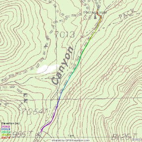 |
| From 20090618 |
Above is the gps tracklog for the short hike up the road. Andrea and Thor went with me, but Andrea's sinus infection conspired against us so it was a short hike. I say it was still productive, because the change from hiking around flat Socorro to hiking up a grade with a backpack definitely took a toll on me.
Most interesting is that, for the first time in my life, I weighed the stuff I took with me to see how bad it was.
| Item | Weight |
| sunglasses | 24g |
| socks | 62g |
| gps | 86g |
| sunscreen | 142g |
| shorts | 218g |
| headlamp | 226g |
| t-shirt | 258g |
| trekking poles | 398g |
| junkbag | 684g |
| first aid kit | 718g |
| water | 864g |
| hammock | 1048g |
| raingear | 1144g |
| shoes | 1236g |
| pack | 2475g |
| digital camera | 12510g |
TOTAL: 22093g
The junkbag is a sack of useful things. It has a U-Dig It shovel, toilet paper, compass, medical allergy tags, whistle, signal mirror, shoelaces, garbage bag, space blanket, two mini maglites (but no batteries) and probably a few other things.
The junkbag aside, I was carrying 22kg of stuff. The things I actually used, not counting the camera, were only 2282g. And of those things, I could have skipped the 86g gps and 398g trekking poles.
I've always packed heavy. I should stop that.
Thursday, June 18, 2009
Other adventures beyond the Magdalena trails
Back in the mid to late 80s me and my friends worried about global thermonuclear war. In the case of a war, we were to gather everything we could find and retreat to a cave in the Magdalena's. I haven't been there since high school. I should go back. It isn't a long hike.
Chaco Canyon is another obvious choice. Even if I didn't need to get in shape, Chaco Canyon is well worth visiting. There are a good handful of trails there.
Up near the Capitan Mountains there is a llama outfitter. They offer day hikes for just under $100 per person. That would be kind of fun.
The Catwalk is a good destination. $3 per person I believe.
Turkey Creek is definitely coming up soon after my testicle gets fixed.
Magdalena Mountain Trails
8 North Baldy Trail
10 Copper Canyon Trail
11 South Baldy Trail
12 Dead Horse Trail
13 Mesa Trail
14 Sixmile Trail
15 South Canyon Trail
17 Ryan Hill Trail
19 West Fork Sawmill Trail
21 Hardy Spring Trail
22 Hardy Ridge Trail
26 Mill Canyon Trail
70 Timber Peak Trail
93 East Fork Sawmill Trail
An obvious goal should be to hike each of them. There aren't many loops in the Magdalena's, so there will be lots of up and down and down and up.

Wednesday, June 17, 2009
Walk: Jun 16, 2009
I took a short walk after gaming. I walked about 2.46 km according to the GPS. I think the track log worked pretty well this time.
I hooked the GPS up to my FreeBSD box, and tried to pull the info. The gpsfetch program doesn't run anymore because it is missing a library. It was compiled Mar 16, 2005. I've installed a whole new OS since then.
I grabbed the garmin-utils package which gave me a gardump command. It's pretty primitive, but I have the raw data now.
# [Track: track name]
# [yyyy-mm-dd hh:mm:ss] lat long [alt] [start]
Track: ACTIVE LOG
2009-06-18 03:46:04 34.050602 -106.893623 1461.822021 start
2009-06-18 03:46:49 34.050709 -106.893669 1461.822021
2009-06-18 03:46:52 34.050709 -106.893669 1461.822021
2009-06-18 03:54:04 34.049957 -106.893517 1428.656494 start
2009-06-18 03:54:40 34.049763 -106.893600 1414.236572
2009-06-18 03:54:59 34.049549 -106.893562 1413.275391
2009-06-18 03:55:17 34.049313 -106.893585 1413.755859
2009-06-18 03:55:37 34.049057 -106.893562 1412.794678
2009-06-18 03:55:54 34.048820 -106.893539 1414.717285
2009-06-18 03:56:12 34.048584 -106.893517 1415.197998
2009-06-18 03:56:32 34.048347 -106.893539 1413.275391
2009-06-18 03:56:51 34.048111 -106.893539 1413.755859
2009-06-18 03:57:10 34.047874 -106.893539 1414.236572
2009-06-18 03:57:28 34.047638 -106.893562 1415.197998
2009-06-18 03:57:46 34.047466 -106.893372 1415.678711
2009-06-18 03:58:05 34.047424 -106.893089 1415.678711
2009-06-18 03:58:32 34.047447 -106.892792 1415.678711
2009-06-18 03:58:53 34.047577 -106.892509 1415.197998
2009-06-18 03:59:09 34.047791 -106.892403 1413.275391
2009-06-18 03:59:25 34.048027 -106.892334 1415.678711
2009-06-18 03:59:42 34.048241 -106.892273 1414.717285
2009-06-18 04:00:00 34.048477 -106.892212 1414.717285
2009-06-18 04:00:18 34.048714 -106.892166 1411.352783
2009-06-18 04:00:37 34.048950 -106.892120 1409.430176
2009-06-18 04:00:55 34.049164 -106.892059 1410.391357
2009-06-18 04:01:11 34.049400 -106.891998 1409.910645
2009-06-18 04:01:28 34.049637 -106.891953 1407.988281
2009-06-18 04:01:43 34.049850 -106.891907 1400.297607
2009-06-18 04:02:09 34.050106 -106.891846 1400.778076
2009-06-18 04:02:27 34.050365 -106.891823 1401.739502
2009-06-18 04:02:44 34.050602 -106.891777 1402.700684
2009-06-18 04:03:03 34.050858 -106.891716 1402.700684
2009-06-18 04:03:20 34.051117 -106.891670 1403.662109
2009-06-18 04:03:37 34.051331 -106.891632 1404.143066
2009-06-18 04:03:58 34.051567 -106.891586 1405.104248
2009-06-18 04:04:16 34.051804 -106.891525 1405.104248
2009-06-18 04:04:34 34.052040 -106.891457 1407.507568
2009-06-18 04:04:50 34.052273 -106.891479 1407.988281
2009-06-18 04:05:08 34.052532 -106.891502 1409.910645
2009-06-18 04:05:27 34.052746 -106.891525 1409.910645
2009-06-18 04:05:46 34.052982 -106.891541 1406.065430
2009-06-18 04:06:07 34.053131 -106.891327 1405.104248
2009-06-18 04:06:27 34.053326 -106.891197 1405.104248
2009-06-18 04:06:45 34.053391 -106.890900 1405.104248
2009-06-18 04:07:02 34.053432 -106.890602 1406.065430
2009-06-18 04:07:18 34.053455 -106.890366 1404.143066
2009-06-18 04:07:36 34.053284 -106.890190 1400.778076
2009-06-18 04:07:50 34.053089 -106.890106 1401.739502
2009-06-18 04:08:07 34.052895 -106.889999 1401.258789
2009-06-18 04:08:26 34.052681 -106.889870 1401.258789
2009-06-18 04:08:46 34.052467 -106.889740 1399.816895
2009-06-18 04:09:03 34.052254 -106.889763 1399.336182
2009-06-18 04:09:20 34.052040 -106.889656 1398.855469
2009-06-18 04:09:40 34.051929 -106.889420 1400.297607
2009-06-18 04:10:00 34.051994 -106.889122 1403.181396
2009-06-18 04:10:17 34.052059 -106.888779 1404.623535
2009-06-18 04:10:37 34.052231 -106.888672 1402.700684
2009-06-18 04:10:58 34.052444 -106.888710 1404.143066
2009-06-18 04:11:16 34.052532 -106.888435 1404.623535
2009-06-18 04:11:32 34.052704 -106.888329 1404.623535
2009-06-18 04:11:50 34.052940 -106.888474 1399.336182
2009-06-18 04:12:07 34.053154 -106.888626 1397.413574
2009-06-18 04:12:24 34.053368 -106.888779 1396.932861
2009-06-18 04:12:42 34.053562 -106.888924 1397.413574
2009-06-18 04:12:51 34.053757 -106.888992 1397.413574
2009-06-18 04:13:06 34.053757 -106.889267 1396.932861
2009-06-18 04:13:22 34.053734 -106.889549 1394.049072
2009-06-18 04:13:37 34.053711 -106.889847 1389.242432
2009-06-18 04:13:55 34.053627 -106.890106 1393.568359
2009-06-18 04:14:12 34.053413 -106.890274 1395.490967
2009-06-18 04:14:32 34.053539 -106.890472 1397.894287
2009-06-18 04:14:50 34.053692 -106.890663 1400.778076
2009-06-18 04:15:07 34.053883 -106.890816 1402.700684
2009-06-18 04:15:24 34.054100 -106.890945 1402.700684
2009-06-18 04:15:41 34.054314 -106.891090 1397.413574
2009-06-18 04:15:59 34.054462 -106.891266 1396.932861
2009-06-18 04:16:20 34.054379 -106.891563 1397.413574
2009-06-18 04:16:41 34.054161 -106.891632 1400.778076
2009-06-18 04:17:05 34.053905 -106.891632 1401.739502
2009-06-18 04:17:25 34.053646 -106.891670 1402.219971
2009-06-18 04:17:43 34.053520 -106.891953 1403.662109
2009-06-18 04:18:00 34.053326 -106.892082 1404.623535
2009-06-18 04:18:18 34.053261 -106.892357 1405.584961
2009-06-18 04:18:36 34.053238 -106.892639 1407.026855
2009-06-18 04:18:54 34.053196 -106.892914 1408.949463
2009-06-18 04:19:12 34.053154 -106.893173 1408.468750
2009-06-18 04:19:30 34.053154 -106.893478 1407.507568
2009-06-18 04:19:49 34.053005 -106.893692 1406.546143
2009-06-18 04:20:09 34.052769 -106.893692 1404.143066
2009-06-18 04:20:27 34.052532 -106.893669 1402.219971
2009-06-18 04:20:47 34.052296 -106.893692 1402.700684
2009-06-18 04:21:09 34.052040 -106.893730 1404.143066
2009-06-18 04:21:27 34.051781 -106.893646 1407.507568
2009-06-18 04:21:45 34.051544 -106.893646 1408.468750
2009-06-18 04:22:05 34.051289 -106.893623 1408.468750
2009-06-18 04:22:20 34.051052 -106.893600 1409.910645
2009-06-18 04:22:38 34.050835 -106.893600 1407.988281
2009-06-18 04:23:00 34.050579 -106.893585 1410.872070
2009-06-18 04:23:18 34.050343 -106.893517 1412.794678
2009-06-18 04:23:36 34.050106 -106.893478 1411.833496
2009-06-18 04:23:53 34.050041 -106.893387 1412.794678
[end transfer, 102/102 records]
Gear update: MSR problems
During gaming tonight I fiddled with my two MSR stoves. The goal was to check all the parts in the pumps. The Dragonfly pump cracked when I reattached the fuel knob. The Whisperlight pump was already cracked when I went to take the fuel knob off to check it. They are both only about eleven years old. I feel cheated.
Tuesday, June 16, 2009
Walk: June 16, 2009
After gaming tonight I went for a walk. Eric Beckstead walked with me. I headed from my house to Cooneys, to Eric's house, to Wal*Mart via 5th street, to Burger King, around Sedillo park and back to my house. I took my GPS with me, but spent much of the walk fiddling with settings. I have a partial track log of the post-Wal*Mart section of the hike. I haven't uploaded a track log in four years, so I'll have to scrounge to figure it out again. Maybe my mac will finally be able to do it without needing to use the FreeBSD machine.
Planning post: June 21, 2009
Sunday I plan to go to Water Canyon and hike up to Blue Mesa. I plan to go in the morning. Currently, I don't know of anyone who wants to go.
Planning post: June 18th 2009
June 18th shall be my first visit with The Mountain. I plan to go to Water Canyon campground and hike up the road to see how far I get. I might have my paper journal by then, if not, I'll improvise. I will GPS it for posterity.
My departure time is still undecided. I'd like people to go with me, but so far I have one maybe. On my own, I'll head up around 15:30 or so.
My departure time is still undecided. I'd like people to go with me, but so far I have one maybe. On my own, I'll head up around 15:30 or so.
Introduction: I "don't have two months"
Earlier this month, in June of 2009, I went to the doctor because of a medical issue. It had been a year and a half since I'd a had a check up, so the doctor looked at a few things. I had gone in with some mysterious swelling, and I left with knowledge that my triglycerides were 900+ and my blood sugar was 400+. I wanted time to think about this and change my lifestyle a little, but the doctor was quite adamant that I didn't have two months. Her exact words were, in fact, "You don't have two months." I'd felt fine, but my A1C is 13+. The swelling is just a hydrocele, and it gets removed soon. The diabetes is a stern shape-up-or-die message.
My long term "retirement" plans had always been mountaineering. Over the long run, the mountain wins. Right now, I'm faced with death by diet. Not a fun prospect. My friend the mountain will provide me with a far better life. I'll be thinner, healthier, and I'll have a lot more fun than I currently do sitting around the house playing World Of Warcraft.
This is my attempt at self-motivation. When I go on adventures, this will be my main journal of them. I can also use it to plan and announce adventures. I plan to cross-post to my other online activities.
Subscribe to:
Posts (Atom)